


Bois saint jean

Gascon
User
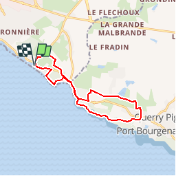

Length
12.7 km

Max alt
29 m

Uphill gradient
120 m
Km-Effort
14.3 km

Min alt
2 m

Downhill gradient
120 m
Boucle
Yes
Creation date :
2015-05-17 00:00:00.0
Updated on :
2015-05-17 00:00:00.0
3h10
Difficulty : Easy

FREE GPS app for hiking
 SityTrail
IGN / Geographical institutes
SityTrail Plus
The world is yours!
About
Trail Walking of 12.7 km to be discovered at Pays de la Loire, Vendée, Les Sables-d'Olonne. This trail is proposed by Gascon.
Positioning
Country:
France
Region :
Pays de la Loire
Department/Province :
Vendée
Municipality :
Les Sables-d'Olonne
Location:
Château-d'Olonne
Start:(Dec)
Start:(UTM)
597374 ; 5146464 (30T) N.
Comments